South Harney Lake Hot Springs
Near Burns, Oregon, United States
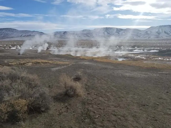
A group of scalding springs on private land at the southeast edge of Harney Lake, among the hottest in the Harney Basin, with no confirmed public access and no built pools.
Closed to the public. Not a confirmed public soak. Federal land-status data puts the spring on private land at the edge of Malheur National Wildlife Refuge, and the most detailed guide lists it as privately owned and closed to the public. Do not visit without the landowner's permission.
- Water temperature
- Not published
- Entry
- Paid
- Getting in
- Drive-up
- Type
- Wild & natural
- Federal land-status data shows the spring on private land right at the edge of Malheur National Wildlife Refuge.
- The source water measures about 150°F66°C, hot enough to scald, and the hot pond has a soft, muddy floor.
- No pools, signs or facilities exist, and the last 8 or so miles are unimproved dirt.
- Older guides describe it as open; the most detailed current guide lists it as closed to the public.
Current status: no confirmed public access
South Harney Lake Hot Springs is not a place we can send you. The springs rise on the southeast edge of Harney Lake, and federal surface-management data from the Bureau of Land Management shows the spot as private land, sitting right against the boundary of Malheur National Wildlife Refuge. The most detailed guide to the site, Hot Springs Locator, heads its page “closed to public” and describes the springs as privately owned.
Some older write-ups say the landowner once let people visit for free, and a few visitors have described soaking here over the years. We could not find any current statement from the owner allowing access, and there is no posted public route, parking area or operator. Until that changes, treat this as a private spring. If you have a genuine reason to visit, such as research or photography, contact the landowner first.
Soakoregon, which tracks springs across the state, lists South Harney Lake among the “unlisted” springs it has not yet documented with a full page.
What the springs are like
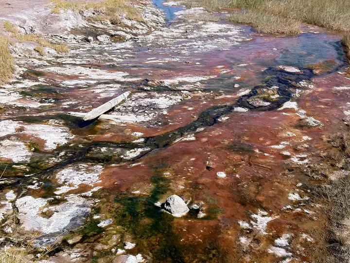
Even with permission, this is not a soaking pool in the usual sense. It is a cluster of very hot vents that feed a small, brightly colored pond, which drains through a narrow channel across flat sagebrush country toward the lake.
The numbers explain why it gets attention:
- Temperature: Oregon’s state geothermal database (based on a 1994 Department of Geology and Mineral Industries survey) records a spot reading of about 153°F67°C at the main vent. Other sources give 140-150°F60-66°C. Either way, the water at the source can scald.
- Flow: about 450 liters per minute (roughly 119 gallons per minute), a strong flow for a desert spring.
- Chemistry: guides describe it as a sodium bicarbonate chloride water with a near-neutral pH and a noticeable sulfur smell.
The spring is often described as one of the two hottest in the Harney Basin. Hot Springs Locator reports that water further down the outflow channel cools to around 100-110°F38-43°C, and that some visitors have used a portable tub filled from the channel rather than getting into the pond. It also notes the muddy, soft bottom and the risk of mites in the warm mud, and does not call it a clean or safe soak.
The USGS Geographic Names Information System labels the feature at these coordinates as Pronghorn Hot Springs, so you may see that name on some maps.
Not to be confused with
Harney Lake has several thermal features, and names get mixed up:
- Harney Lake Hot Springs, a group of about five vents on the southwest shore, recorded at about 104°F40°C in the state database.
- A warm spring in Harney Lake itself, near the southeast shore, recorded at about 72°F22°C.
All of these are on or next to the refuge and none is a recognized public soak.
Getting there
We are not publishing turn-by-turn directions, because there is no confirmed public access. For orientation: the springs are roughly 34 miles south of Burns, at around 4,100 feet, south of the playa of Harney Lake. Hot Springs Locator says the last 8.5 miles are unimproved dirt roads that are likely to be snowy or very muddy in winter and spring, and recommends waiting until midsummer for any trip into the area. Much of the surrounding land is either refuge or private ranch land, and refuge rules restrict where you can drive and walk.
When to go
There is no public season. If you are in the area for the refuge, spring and fall bird migrations are the main reason to visit the Harney Basin, and the refuge has a headquarters and visitor area south of Burns. Expect hot, dry summers, very cold winters, and dirt roads that turn to mud after rain or snowmelt.
Rules and etiquette
- Private land: stay off without the owner’s permission. Trespassing harms the slim chance of access for anyone else.
- Refuge land: Malheur National Wildlife Refuge prohibits swimming, and parts of the refuge are closed to entry. Harney Lake is part of the refuge.
- No vehicles off-road. The playa and the lake margins are soft and easy to damage.
- Leave no trace. If you ever visit with permission, carry everything out.
Where to stay nearby
Burns and neighboring Hines have motels, restaurants and fuel and are the base for most trips into the Harney Basin. To the south, Frenchglen has a small historic hotel at the foot of Steens Mountain.
For campers, the BLM’s Page Springs Campground near Frenchglen is the usual base on the west side of Steens Mountain.
Where to soak legally instead
- Alvord Hot Springs on the east side of Steens Mountain is a privately run soak with camping and bunkhouses. Call ahead if you only want a day soak.
- Willow Creek Hot Springs, far to the south near the Nevada line, is a free BLM pool with camping beside it.
- Barnes Warm Springs near Frenchglen is a pleasant walk to a historic homestead, but soaking there is banned because it is on refuge land.
Safety notes
- Scalding water: source temperatures around 150°F66°C can cause severe burns in seconds. Never put a hand or foot into the hot pond or the upper channel.
- Unstable ground: the ground around thermal vents can be thin crust over hot mud. Stay well back.
- Remoteness: this is empty country with long dirt roads, little traffic and patchy cell service. Carry water, a spare tire and a way to call for help.
- Mud: the soils around Harney Lake turn into deep mud when wet. Do not drive them after rain.
Map and nearby springs
GPS: 43.18112, -119.05735
South Harney Lake Hot Springs: common questions
Is South Harney Lake Hot Springs open to the public?
Not as far as we can confirm. Federal surface-management data shows the springs on private land, and the most detailed guide to the site lists it as privately owned and closed to the public. Some older write-ups say the owner used to allow visitors, but we found no current statement from the landowner. Do not go without permission.
How hot is South Harney Lake Hot Springs?
Very hot. Oregon's state geothermal database records a spot reading of about 153°F67°C at the main vent, and other sources give 140-150°F60-66°C. That is hot enough to cause serious burns. Water downstream in the outflow channel has been reported at around 100-110°F38-43°C, but the ground around the vents is soft and unsafe.
Where exactly is South Harney Lake Hot Springs?
At the southeast edge of Harney Lake in Harney County, roughly 34 miles south of Burns. The USGS place-name database labels the spring at this spot Pronghorn Hot Springs.
Can I soak in Harney Lake or elsewhere on Malheur National Wildlife Refuge?
No. Harney Lake is part of Malheur National Wildlife Refuge, and refuge rules prohibit swimming. That is also why the old soaking pool at Barnes Warm Springs near Frenchglen is closed.
Where can I legally soak near Burns instead?
Alvord Hot Springs, on the east side of Steens Mountain, takes campers and day visitors who call ahead. Willow Creek Hot Springs, much farther south near the Nevada line, is a free BLM soak with camping.
Closest hot springs to South Harney Lake Hot Springs
Near Frenchglen
Wild & natural
99-102°F37-39°C
Resort or spa
Hart Mountain Hot Springs
Oregon, United States
57 mi away, ~1.5 hr drive
100-105°F38-41°C Free Drive-up
All hot springs in OregonAll hot springs in United StatesOpen the full map