Hart Mountain Hot Springs
Near Plush, Oregon, United States
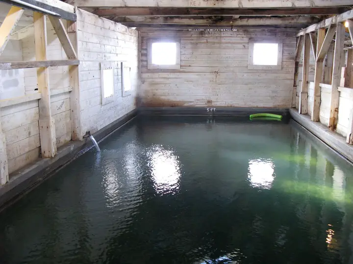
A stone-walled soaking pool beside a free, first-come campground on Hart Mountain National Antelope Refuge, with a smaller primitive spring a minute away and pronghorn country all around.
Photos: Finetooth (CC BY-SA 3.0); Gary Halvorson, Oregon State Archives (CC BY 4.0). Resized and cropped for this page.


- Water temperature
- 100-105°F38-41°C
- Entry
- Free
- Getting in
- Drive-up
- Type
- Wild & natural
- The main pool, roughly 10 by 15 feet, sits inside a rock wall with a concrete deck, benches and a ladder.
- A second, undeveloped spring is about a one-minute walk from the main pool.
- Camping at Hot Springs Campground is free, walk-up only, with vault toilets and no drinking water.
- Summer and fall 2026: a waterline project shuts off water at refuge headquarters and may cause stops on Hot Springs Road.
What to expect
Hart Mountain Hot Springs is the reason a lot of people drive to the far side of Lake County. The spring rises at the eastern foot of Warner Peak on Hart Mountain National Antelope Refuge, a high sagebrush plateau the federal government set aside in 1936 to protect pronghorn. The U.S. Fish and Wildlife Service manages it, and it is very different from a national forest: it is run for wildlife first, and recreation is regulated around that.
The developed spring is a single pool roughly 10 by 15 feet, enclosed by a stone wall that blocks the wind and gives a bit of privacy from the campground. Inside there is a concrete deck with benches and a ladder down into the water. The pool usually sits around 100 to 105°F38 to 41°C, warm enough to take the edge off a cold desert night without being scalding.
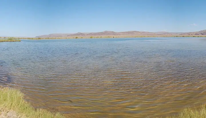
About a minute away there is a second spring that has never been built up. Walk back toward the parking area and take the path to the left. It has no walls or deck, just a natural pool in the ground, and people who have used both often describe it as a little warmer than the main pool.
There are no staff at the springs and no changing rooms. The setting is open sagebrush country with campsites strung along Rock Creek and long views of the mountain. Pronghorn, mule deer and California bighorn sheep all live on the refuge, and the Fish and Wildlife Service counts close to 250 bird species.
Getting there
The refuge is remote even by eastern Oregon standards. Fill the tank and buy groceries before you leave Lakeview or Plush.
- From Lakeview: Head north on US-395 to the OR-140 junction, then go east on OR-140 for 15.6 miles. Turn north on the Plush Cutoff (County Road 3-13) and continue about 19.6 miles through Plush, which has gas, a small store and a restaurant. Turn east on Hart Mountain Road (County Road 3-12) and climb 23 miles to refuge headquarters. You pass the Warner Valley wetlands at about 2 miles and Camp Hart Mountain Campground at about 13.5 miles. The first 13.5 miles are paved and the rest is maintained gravel. The Fish and Wildlife Service calls this the route with the best road conditions.
- From Frenchglen or Burns: The Hart Mountain-Frenchglen Road crosses the plateau from the east on maintained gravel. From Bend or Burns you can also come down US-20 and Hogback Road.
From headquarters, follow Hot Springs Road south about 4 to 5 miles to Hot Springs Campground. The pool sits by the parking area, so most people walk under a minute from the car. Beyond the campground the road toward Barnhardi Cabin gets rough and rocky, and many refuge roads past this point need high clearance or 4WD.
Stop at headquarters on the way in. The building is open around the clock for information, though not always staffed, and the visitor center keeps short hours, mostly on summer weekends.
When to go
Late spring to early fall is the practical season. The gravel is dry, the campground is open and the days are long. Summer weekends bring more campers than you might expect for somewhere this far out, so arrive on a weekday if you want the pool to yourself.
Fall is cold at night and often very clear, which suits a soak after dark. Hunting is allowed on the refuge during set seasons, so wear something bright if you walk away from the road.
Winter is possible but hard. The refuge gets about 12 inches of precipitation a year, most of it as winter snow, and the gravel sections and side roads can become impassable. Spring rain turns the dirt roads to mud. Call refuge headquarters at (541) 947-2731 before a cold-season trip.
Summer and fall 2026: a waterline project at refuge headquarters and along Hot Springs Road runs from July 1 to late fall. Water is shut off at headquarters and the visitor center, and you may be stopped by construction on the drive to the springs.
Rules and etiquette
- No fee. The refuge, the springs and Hot Springs Campground are all free.
- Camping only in designated campgrounds. You can stay up to 14 days in any 30-day period. Camping on roads or in pull-offs is not allowed, and trailers longer than 24 feet are not permitted.
- Clothing. We could not find a posted clothing rule for the springs on the refuge’s pages. The pool sits next to a family campground, so bring a suit and be considerate of whoever is already there.
- Keep the pool clean. No soap, shampoo or glass in or near the water. The pool is small and the flow cannot clear it fast.
- Share. If people are waiting by the wall, keep your soak short and move to the primitive spring.
- Wildlife first. Drive only on open roads and give pronghorn and bighorn plenty of room. Leave artifacts and old ranch relics where you find them.
Where to stay nearby
- Hot Springs Campground is the obvious base, a few steps from the pool. ONDA counts 29 sites, many tucked along Rock Creek and outlined with buck and rail fence. It has vault toilets but no drinking water.
- Camp Hart Mountain Campground, on Hart Mountain Road below headquarters, has a pavilion with potable water and vault toilets, which matters in 2026 while the headquarters water is shut off.
- Backcountry camping on the refuge needs a permit from the Fish and Wildlife Service.
- Plush has gas, groceries and a restaurant. Lakeview, roughly 65 miles away by the route above, is the nearest town with motels, fuel and a full grocery store, and it is also where you will find Hunter’s Hot Springs.
Safety notes
- Remoteness: There is no cell service on the refuge and help is a long way off. Carry a spare tire, extra water, food and warm layers, and tell someone your plans.
- Water: Bring all the drinking water you need. Do not drink from the springs or Rock Creek without treatment.
- Heat and altitude: The campground sits high on the plateau and nights are cold even in summer. Long soaks followed by cold air can make people lightheaded. Get out slowly and drink water.
- Footing: The deck and ladder get slick, and the primitive spring has soft natural banks.
- Hot spring hygiene: Keep your head above water. Warm, untreated pools can carry bacteria and amoebae.
- Weather: Thunderstorms build fast in summer and the gravel roads turn greasy when wet.
Nearby stops worth adding
The Warner Valley wetlands at the foot of Hart Mountain are worth a slow drive for birds in spring. If you continue east across the refuge toward Frenchglen, you reach the Steens Mountain area and Malheur National Wildlife Refuge, home of Barnes Warm Springs, where the pool is now closed to soaking but the walk to the old homestead is open. Alvord Hot Springs is on the far side of Steens Mountain and makes a long loop possible.
Map and nearby springs
GPS: 42.50116, -119.69018
Hart Mountain Hot Springs: common questions
Is Hart Mountain Hot Springs free?
Yes. The U.S. Fish and Wildlife Service charges no fee to visit Hart Mountain National Antelope Refuge, and camping at Hot Springs Campground is free on a first come, first served basis.
How hot is the water at Hart Mountain Hot Springs?
The developed pool is usually about 100 to 105°F38 to 41°C. Visitors often report the small primitive spring nearby as a little warmer. Test it by hand before you get in.
Can you camp at the Hart Mountain hot springs?
Yes. Hot Springs Campground sits a short walk from the pool. Sites are walk-up only, the refuge limits stays to 14 days in any 30-day period, trailers can be no longer than 24 feet, and there is no drinking water.
How do you get to Hart Mountain Hot Springs?
From Lakeview, take OR-140 east, turn north on the Plush Cutoff, drive through Plush and take Hart Mountain Road east up to refuge headquarters. The road is paved for 13.5 miles, then maintained gravel. The campground and springs are about 4 to 5 miles south of headquarters.
Is there drinking water at Hart Mountain?
Not at Hot Springs Campground. Normally there is water at refuge headquarters, but a 2026 waterline project has it shut off from July 1 to late fall. Use the pavilion at Camp Hart Mountain Campground or bring all you need.
Closest hot springs to Hart Mountain Hot Springs
Near Adel
Wild & natural
104°F40°C
Resort or spa
Near Frenchglen
Wild & natural
Near Burns
Wild & natural
All hot springs in OregonAll hot springs in United StatesOpen the full map