Bumpass Hell Trail
Near Mineral, California, United States
A 3-mile round-trip walk to the largest hydrothermal area in Lassen Volcanic National Park, where boardwalks cross boiling pools, mudpots and steam vents. This is a viewing walk only. Bathing is prohibited.
Photos: Amanda Sweeney (Public domain); Wsiegmund (CC BY 2.5); inkknife_2000 (7.5 million views +) (CC BY-SA 2.0); DimiTalen (CC0). Resized and cropped for this page.


- Water temperature
- Not published
- Entry
- Paid
- Getting in
- Hike in
- Type
- Public pool
- You cannot bathe here. The water is acidic and close to boiling, and the ground crust can break. Stay on the trail and boardwalk.
- The basin covers about 16 acres and is the biggest hydrothermal area in the park.
- The first mile is a gentle climb with an overlook of the remnant peaks of ancestral Brokeoff Volcano.
- Snow usually keeps the trail closed until early summer. In 2026 it opened June 26.
Read this first: no bathing
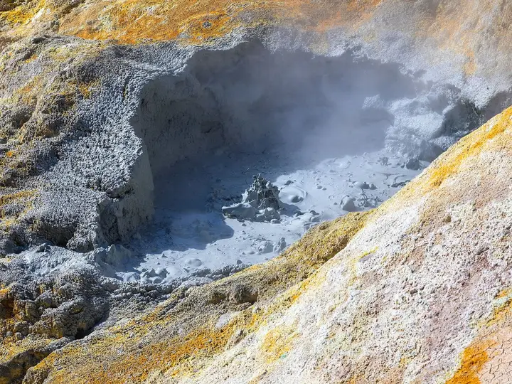
Bumpass Hell is not a soaking spring. It is the largest hydrothermal area in Lassen Volcanic National Park, and the water here is acidic and close to boiling. The highest water temperature recorded at Bumpass Hell is about 198°F92°C, close to the boiling point at this altitude. Contact with the water or mud can burn skin. The ground around the features can be a thin crust over boiling water or mud.
The National Park Service is clear: stay on established trails and boardwalks. People who walked off them have been seriously injured. Treat this listing as a walk to look at hot springs, not to get into one.
What to expect
The trail starts from a parking area high on the Lassen Volcanic National Park Highway, at about 8,200 feet. It is 3 miles round trip, and the whole route sits between 8,200 and 8,400 feet.
The first mile is a gradual climb on packed gravel and dirt, about 4 feet wide, with almost no shade. About half a mile in, an overlook shows the five remnant peaks of ancestral Brokeoff Volcano, the much larger mountain that once stood here. At roughly the 1-mile mark you reach the basin overlook and get your first full look down into Bumpass Hell: pale, mineral-stained ground, steam drifting off pools and the smell of sulfur.
From there the trail descends into the basin on a narrower path with rock steps. NPS gives the drop as about 200 to 300 feet. At the bottom, a boardwalk loops among the features: bubbling mudpots, steaming fumaroles, and pools tinted grey, turquoise and yellow. The basin covers about 16 acres. A second overlook on the eastern edge gives a different angle. Then you climb back out the way you came.
There are no restrooms on the trail or in the basin. Vault toilets are at the trailhead only.
Getting there
Bumpass Hell is in the southwest part of Lassen Volcanic National Park, in Shasta County. The trailhead parking area is on the main park highway (State Route 89 through the park), about 7 to 8 miles north of the Southwest Entrance, depending on which NPS figure you use.
- From Red Bluff or Chester: Take State Route 36 to the community of Mineral, where the park headquarters is, then head north on State Route 89 to the Southwest Entrance and the Kohm Yah-mah-nee Visitor Center. Continue up the park highway to the signed Bumpass Hell parking area.
- From Redding: Take State Route 44 east to the park’s northwest entrance at Manzanita Lake, then drive the park highway south over the high section of road to the trailhead. This route is longer but scenic.
The park highway closes to through traffic each winter, typically once major storms arrive in November or December, and does not fully reopen until crews clear the snow in late spring. Even when the road is open, the trail can still be under snow.
Parking is limited. NPS says the lot is often full from mid-morning to early afternoon, especially on weekends. Arrive early or late in the day.
When to go
The trail is open only in the snow-free months. NPS lists the season as roughly late July through October in one place and says it usually opens by the Fourth of July weekend in another. It depends entirely on snowpack:
- In 2026 the trail opened June 26, after a lighter winter.
- In 2019 it did not open until September 13.
- In 2018 it never opened.
Late July through September is the most reliable window. Early mornings and late afternoons are quieter, and weekdays beat weekends. By October, nights are cold, storms can drop early snow and the season can end without warning. If you are planning a visit in mid to late October, check the park’s current conditions page the day before.
Rules and etiquette
- Entrance fee. There is no trail fee, but you need a park entrance pass. In 2026 that is $30 per private vehicle, $25 per motorcycle, or $15 per person on foot or bike from April 16 to November 30. Winter rates are $10. A Lassen annual pass is $55. America the Beautiful passes are accepted.
- No reservations are needed for the park or this trail.
- No bathing, wading or touching the water or mud.
- Stay on trails and boardwalks. This is both a safety rule and a park regulation.
- No pets. Dogs and other pets are not allowed on any park trail, even in carriers. Service animals are allowed.
- Leave rocks and minerals where they are. Do not throw anything into the pools.
Where to stay nearby
- Southwest Campground sits beside the Kohm Yah-mah-nee Visitor Center near the Southwest Entrance, the closest park campground to the trailhead. It is first come, first served. In winter, only self-contained vehicles may stay in the parking lot.
- Other park campgrounds include Manzanita Lake in the northwest corner, a longer drive from this trailhead. Check the park website for current seasons and booking.
- Mineral, just outside the Southwest Entrance, is the nearest small community. Chester, on Lake Almanor to the southeast, and Red Bluff and Redding to the west have more lodging, food and fuel.
Safety notes
- Boiling, acidic water. Never leave the boardwalk or trail inside the basin. The crust can be thinner than it looks, and the water and mud can cause serious burns.
- Footing. Knee and ankle injuries are the most common visitor injuries in the park. The descent into the basin has rock steps and steeper slopes. NPS trail notes suggest trekking poles for the steep section.
- Altitude and sun. At 8,200 to 8,400 feet, the air is thin and shade is scarce. Bring a hat, sunscreen and plenty of water, and take it slowly if you have heart or lung conditions.
- Lingering snow. Snow patches can persist into summer on shaded sections of trail, even after the trail officially opens.
- Fumes. The rotten-egg smell is hydrogen sulfide. If you feel unwell in the basin, move upwind and climb back out.
Nearby stops worth adding
Sulphur Works, near the Southwest Entrance, has roadside steam vents and mudpots you can see from a short walkway, which is handy if Bumpass Hell is still under snow. The Lassen Peak Trail starts a short drive up the road and climbs to the summit of the volcano when snow allows.
Map and nearby springs
GPS: 40.46606, -121.51404
Bumpass Hell Trail: common questions
Can you swim or soak at Bumpass Hell?
No. Bumpass Hell is a hydrothermal viewing area, not a hot spring for bathing. The pools and mud are acidic and near boiling, and the thin crust around them can collapse. The National Park Service requires you to stay on established trails and boardwalks, and visitors who stepped off have been seriously burned.
How long is the Bumpass Hell Trail?
It is 3 miles round trip. The first mile climbs gently to an overlook, then the trail drops about 200 to 300 feet into the basin. NPS estimates 90 minutes to 2 hours, depending on pace and time spent on the boardwalk.
When does the Bumpass Hell Trail open?
Only after the snow melts. It typically opens around early July and stays open through October, but the date varies a lot. In 2026 it opened June 26. In 2019 it did not open until September 13, and in 2018 it never opened. Check the NPS trail conditions page before you go.
Do you need to pay to hike Bumpass Hell?
There is no separate trail fee or permit, but you must pay the Lassen Volcanic entrance fee or hold a valid pass. In 2026 that is $30 per private vehicle from April 16 to November 30.
Is Bumpass Hell good for kids?
Mostly. NPS says children 5 and older can usually manage the flat first mile, but the last half mile into the basin has rock steps and steeper slopes. Hold small children's hands on the boardwalk.
Why is it called Bumpass Hell?
It is named after Kendall Vanhook Bumpass, a local settler who had a mining claim here. In 1865 he broke through the crust into a scalding mudpot while showing the area to a newspaper editor, and the injury later cost him his leg.
Closest hot springs to Bumpass Hell Trail
95-112°F35-44°C
Resort or spa
100-110°F38-43°C
Wild & natural
Eagleville Hot Springs (Squaw Baths)
California, United States
92 mi away, ~2.5 hr drive
100-110°F38-43°C Free Short walk
Near Kings Beach
Resort or spa
All hot springs in CaliforniaAll hot springs in United StatesOpen the full map
Sources we checked (6)
- nps.gov/thingstodo/hikebumpasshell.htm
- nps.gov/lavo/planyourvisit/fees.htm
- nps.gov/lavo/planyourvisit/trail-conditions.htm
- en.wikipedia.org/wiki/Bumpass_Hell
- visitplumas.org/get-outside/hiking/bumpass-hell
- activenorcal.com/the-road-through-lassen-volcanic-just-opened-for-2026-heres-whats-accessible-and-whats-not/