McCredie Hot Springs
Near Oakridge, Oregon, United States
Shallow rock-and-gravel pools on both banks of Salt Creek, a few minutes from a paved day-use lot on Highway 58 east of Oakridge, at the site of a long-gone resort.
- Water temperature
- 98-114°F37-46°C
- Entry
- Paid
- Getting in
- Short walk
- Type
- Wild & natural
- The day-use lot is right on Highway 58, so this is one of the easiest wild soaks in the Oregon Cascades to reach.
- The spring water leaves the ground at about 163°F73°C and mixes with creek water in the pools, so temperatures shift from pool to pool.
- Pools on the far (south) bank of Salt Creek are usually quieter, but only reachable when the creek is low enough to cross.
- The site was a resort and Portland Beavers baseball training camp in the early 1900s. Nothing of it remains.
What to expect
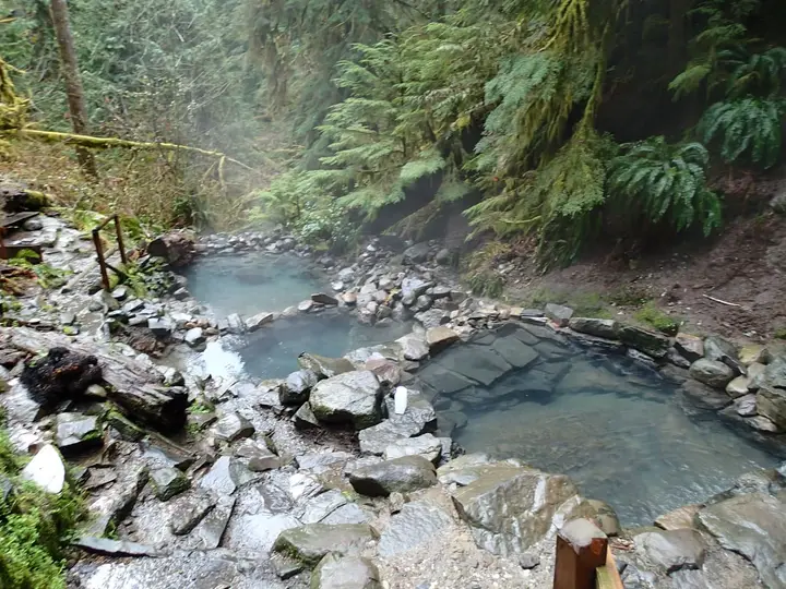
McCredie Hot Springs is the roadside option in the Oregon Cascades. Hot water seeps out along both banks of Salt Creek, a fast, cold tributary of the Middle Fork Willamette River, and visitors have stacked creek rocks into a handful of shallow pools where the spring water and the creek mix. Expect somewhere between two and four usable pools, depending on the season and how recently someone rebuilt the walls.
The water is hot at the source. State and federal spring surveys put it at about 163°F73°C, flowing at roughly 20 gallons a minute. In the pools it is usually somewhere between 98°F and 114°F37°C and 46°C, but that changes a lot with creek level. Move a few rocks’ width toward the creek and it cools fast. Move toward a vent and it can get too hot to stand in.
The pools are only 1 to 2 feet deep, with gravel and silt bottoms, and the water is often cloudy. This is not a scenic terrace like Umpqua Hot Springs. It is a shallow soak under big conifers with the sound of the creek, and the highway traffic, close by.
The pools on the day-use (north) side of the creek get most of the traffic and are often in rougher shape. The south-bank pools across Salt Creek are usually quieter and better maintained, but you can only reach them by wading the creek when it is low.
Getting there
McCredie sits right beside Oregon Route 58 (the Willamette Highway) in the Willamette National Forest.
- From Eugene: Take I-5 south to the OR-58 exit and follow OR-58 east past Lowell and through Oakridge. About 10.7 miles past Oakridge, look for the blue hot springs sign between mileposts 45 and 46 and turn right into the large paved parking area.
- From Bend or US-97: Head west on OR-58 over Willamette Pass, past Salt Creek Falls. The lot is on your left about 10 miles before Oakridge.
The Forest Service rebuilt this lot as a day-use site around 2012, with toilets, signs and picnic tables. A short, flat path leads from the lot down to the north-bank pools in a few minutes. Wear shoes with grip. The bank is muddy and the creek rocks are slick.
In winter the lot is generally plowed, but the path can be icy.
When to go
Late summer and fall are the reliable months. Salt Creek drops, the pools are above water and the temperatures settle into a comfortable range.
Spring snowmelt is the problem season. In a normal year, roughly May into June, Salt Creek runs high and covers or chills the creekside pools. Visitors have reported the north-bank pools still underwater in late June while the south-bank pools were usable, but crossing the creek at that time of year is dangerous.
Winter soaks can be good on a dry, cold day, and you have the advantage of a plowed highway lot. Check the Oregon Department of Transportation’s TripCheck for chain requirements on OR-58 if you are coming over Willamette Pass.
Weekends and holidays are very busy because the site is so easy to reach. Come on a weekday morning if you want space. You must be gone by sundown.
Rules and etiquette
- Day use only. Willamette National Forest Order 06-18-10-23-18 prohibits being in the listed Middle Fork Ranger District areas between sundown and sunrise and parking against posted signs. The sections it covers include the McCredie area and the first 850 feet of Shady Gap Road (FR 5875) to the Salt Creek bridge. The order is set to run until December 31, 2026, so look for a renewal notice. Violations can carry fines of up to $5,000.
- No camping at the springs or in the lot.
- Pay to park. Guides report a $5 per vehicle day-use fee, or a Northwest Forest Pass. Read the fee board at the lot.
- Clothing is optional by custom. Nudity is common, though many people wear suits. There is no site-specific nudity rule like the one at Terwilliger Hot Springs farther north.
- No glass. Broken glass in a gravel-bottom pool is a real injury risk.
- Pack out everything, including food scraps and cans. Keep dogs leashed.
Where to stay nearby
There is no lodging at the springs. The closest bases:
- Blue Pool Campground, about half a mile west on OR-58, has 24 sites in old-growth forest along Salt Creek, with a large picnic area. Sites are reservable on Recreation.gov.
- Packard Creek Campground on Hills Creek Reservoir, south of Oakridge, is a larger option with lake access.
- Oakridge, about 10 miles west, has motels, groceries, fuel and brewpubs. It is also the hub for the area’s mountain bike trails.
Fire restrictions often apply in summer and fall, so check current Willamette National Forest fire rules before planning a campfire at any campground.
Safety notes
- Hot spots: The source water is about 163°F73°C. Pockets near the vents can scald, especially where the creek has dropped. Test water with your hand before you step in, and keep children and dogs out of the vent areas.
- Creek crossing: Salt Creek is cold and fast. Do not try to cross to the south-bank pools during snowmelt or after heavy rain.
- Water quality: The pools are shallow, warm and unchlorinated. Keep your head above the water, do not drink it, and shower afterward. One 2025 visitor comment reported skin bites after a soak, which is a reminder that small warm pools can carry insects and bacteria.
- Highway lot: This is a busy roadside site. Lock your car, keep valuables out of sight and be aware of who is around after dark. That is one reason the night closure exists.
History
Settlers knew these springs by the late 1800s. In the 1910s the site was developed as Winino Springs, and Judge William Wallace McCredie later took over the lease and ran it as McCredie Springs, a resort that also served as a training camp for his Portland Beavers baseball club. Southern Pacific trains brought guests through the 1930s. The hotel burned in 1958, and the Christmas flood of 1964 took out the bridge and damaged the pool. The Forest Service later cancelled the lease and removed what was left, leaving the springs much as you see them today.
Nearby stops worth adding
Salt Creek Falls, about 11 miles east on OR-58, is one of the tallest waterfalls in Oregon and has a short paved walk to a viewpoint. Waldo Lake and the Willamette Pass area are a little farther east. If you want a second soak, Umpqua and Terwilliger are both day trips away, but neither is on OR-58.
Map and nearby springs
GPS: 43.70595, -122.28798
McCredie Hot Springs: common questions
Where is McCredie Hot Springs?
On Salt Creek beside Oregon Route 58 in the Willamette National Forest, about 10.7 miles east of Oakridge and about 51 miles southeast of Eugene. The signed day-use lot is on the right between mileposts 45 and 46 if you are driving east.
Is McCredie Hot Springs open at night?
No. It is a day-use site, and a Willamette National Forest order for the Middle Fork Ranger District prohibits being in the listed areas around the springs between sundown and sunrise. That order runs to December 31, 2026, so check whether it has been renewed. Camping at the springs is not allowed.
How hot is McCredie Hot Springs?
The source is about 163°F73°C according to state and federal spring surveys. The pools you actually sit in are usually reported between 98°F and 114°F37°C and 46°C, depending on how much creek water gets in. Some pockets near the vents are far hotter, so test with a hand.
Do you need a pass to park at McCredie Hot Springs?
Expect to pay. Visitor guides report a $5 day-use fee per vehicle, or a Northwest Forest Pass. The Forest Service does not list the rate online, so read the fee sign when you arrive and carry cash.
Is McCredie Hot Springs clothing optional?
Nudity has long been common here and is not banned by any order we could find for this site. Plenty of visitors wear swimsuits. Because it sits next to a highway lot, you will see a mix of both.
Why are the pools sometimes underwater?
The pools are built from rocks along the creek bank. During spring snowmelt, Salt Creek rises over them and they can be cold or unsafe. Late summer and fall are the most reliable months.
Closest hot springs to McCredie Hot Springs
95-98°F35-37°C
Wild & natural
Wall Creek Warm Springs (Meditation Pool)
Oregon, United States
7 mi away, ~10 min drive
95-98°F35-37°C Free Short walk
Terwilliger (Cougar) Hot Springs
Oregon, United States
26 mi away, ~40 min drive
85-112°F29-44°C Paid Short walk
102-104°F39-40°C
Wild & natural
Bigelow Hot Springs (Deer Creek Hot Springs)
Oregon, United States
39 mi away, ~1 hr drive
102-104°F39-40°C Free Short walk
90-115°F32-46°C
Wild & natural
All hot springs in OregonAll hot springs in United StatesOpen the full map