Hutlinana Hot Springs
Near Manley Hot Springs, Alaska, United States
A single hot-tub-sized pool walled off from a cold creek in the spruce and muskeg of Interior Alaska, reached by an unmarked trail of about 6 miles from the Elliott Highway, mostly in winter.
- Water temperature
- 106°F41°C
- Entry
- Free
- Getting in
- Long hike
- Type
- Wild & natural
- One pool, about the size of a hot tub, separated from the cold creek by a low rock wall.
- Warm water keeps the creek open beside the pool even in midwinter.
- The trail is about 6 miles each way across frozen muskeg and forest, and is not signed.
- There are no facilities of any kind, so this is a winter camping trip.
What to expect
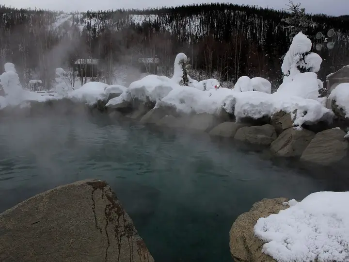
Hutlinana Hot Springs is about as basic as a hot spring gets. There is one pool, roughly the size of a hot tub, at the edge of Hutlinana Creek in the spruce forest and muskeg east of the Elliott Highway’s last stretch toward Manley. A low wall of rocks, sometimes patched with a plank by earlier visitors, keeps the cold creek out. The spring water sits at about 106°F41°C, and its warmth keeps the creek beside it open in the middle of an Interior winter.
There are no buildings, signs, outhouses or tables. You are a day’s ski or snowshoe from the road, the nearest town is Manley Hot Springs, and that is the point. Most visitors come in winter with sleds and tents, soak in the evening, and ski out the next day.
The spring flows at roughly 110 gallons a minute. Beaver dams on the creek occasionally back water up and flood the pool area, so the pool you find may not match the last trip report.
Who manages the land
Federal land-status maps show the springs and the country between them and the highway as state land, not BLM or national forest land. No agency develops or maintains the site. State land rules apply, and there is no fee or permit for a private trip. If you plan a large group or a commercial trip, check with the Alaska Department of Natural Resources first.
Getting there
From Fairbanks, take the Steese Highway north to Fox and turn onto the Elliott Highway. The Elliott is paved to the Dalton Highway junction at about mile 73 and gravel beyond, so check whether your rental contract allows gravel roads. Continue past Livengood and the Dalton junction toward Manley.
The trailhead is near the Hutlinana Creek bridge. A Fairbanks Daily News-Miner group parked at a small pullout just west of the bridge at mile 129.3. Other descriptions put the trail start around mile 128, before the bridge, and suggest looking for a pullout or old road on the east side of the highway. The trail is not marked, so carry a GPS track and a map.
The route runs about 6 miles across flat-to-lumpy muskeg and through spruce forest, and estimates run to 8 miles depending on the winter and the line you take. The News-Miner party crossed the creek about a quarter mile in on a logjam (the creek was still open that November), climbed over dozens of fallen trees, and needed about four hours on skis and snowshoes.
When to go
After freeze-up is the normal season, once the muskeg and the creek crossing are frozen hard. Early winter can still leave the creek open, as the 2015 trip found. February and March give you longer days and deep, settled snow, though temperatures can still fall far below zero.
Spring breakup is the worst time: overflow ice can flood the trail and the creek crossing gets dangerous. Summer is possible on foot, but the muskeg is wet and slow, and mosquitoes are heavy.
Rules and etiquette
There are no posted rules, so the usual backcountry ones are what matter:
- Pack out everything, including food scraps and toilet paper.
- Do not wash with soap in the pool or the creek.
- Leave the rock wall as you found it or repair it if it has slumped. Do not dig new pools or reroute the creek.
- Camp back from the water so you do not trample the warm, thawed ground around the spring.
- Clothing: Nobody else is likely to be there. Expect people to soak however they like.
- Fires: Use dead and down wood only, keep fires small, and check for any state burn restrictions before you go.
Where to stay nearby
- At the springs: Tent camping near the pool is the usual plan. The ground near the springs may carry less snow.
- Manley Hot Springs: The small town at the end of the Elliott Highway, about 23 road miles past the trailhead, has municipal riverside camping, the historic Manley Roadhouse, and a separate soaking spot with three concrete tubs in a private greenhouse ($5 when last listed; arrange it in town and confirm it is running).
- Along the Elliott: Olnes Pond and Whitefish campgrounds near the start of the highway, and informal camping at the Tolovana River bridge around mile 75.
- Fairbanks: Full services, roughly 140 road miles back.
Safety notes
- Cold: This is a winter camping trip in Interior Alaska. Bring a sleeping system rated well below the forecast, insulated pads, and a way to dry clothes. Getting out of a 106°F41°C pool into subzero air is the risky moment, so have dry layers ready before you stand up.
- Creek and overflow ice: Open water at the crossing and overflow on the trail can soak boots and gear. Carry spare socks and know how to check ice.
- Navigation: The trail is unsigned and drifts in. Carry a GPS, map and compass, and turn back if you lose the route.
- Remoteness: There is no cell service. Leave a trip plan, carry a satellite messenger, and be ready to self-rescue. Help can be many hours away.
- Wildlife: Moose use the creek bottoms year-round. Give them a wide berth, especially in deep snow, when they are less willing to move off a trail.
- Fuel: Fill up in Fairbanks. Services along the Elliott are scarce.
Map and nearby springs
GPS: 65.20917, -149.99250
Hutlinana Hot Springs: common questions
Where is the trailhead for Hutlinana Hot Springs?
On the Elliott Highway near the Hutlinana Creek bridge, about 140 road miles from Fairbanks. A Fairbanks News-Miner trip parked at a small pullout just west of the bridge at mile 129.3; other descriptions put the start around mile 128. The trail is not signed.
How long is the hike to Hutlinana Hot Springs?
About 6 miles each way, and some accounts say up to 8 depending on the route and the winter. A group on skis and snowshoes took about four hours to get in.
Can you visit Hutlinana Hot Springs in summer?
It is possible but hard. The trail crosses muskeg that is wet and boggy when thawed, and the creek crossing is harder. Most people go in winter after freeze-up. In spring, overflow ice can spread over the trail.
How hot is Hutlinana Hot Springs?
About 106°F41°C, according to published accounts. The pool sits next to a cold creek and is held apart from it by rocks, so the temperature can drop if the wall leaks or the creek floods.
Can you camp at Hutlinana Hot Springs?
Yes. People pitch tents near the pool on winter trips. There is no cabin, outhouse or shelter, so bring a full winter camping kit.
Closest hot springs to Hutlinana Hot Springs
Near Manley Hot Springs
Resort or spa
Near Fairbanks
Resort or spa
Wild & natural
Near Ruby
Wild & natural
All hot springs in AlaskaAll hot springs in United StatesOpen the full map
Sources we checked (4)
- en.wikipedia.org/wiki/Hutlinana_Hot_Springs
- newsminer.com/features/outdoors/hutlinana-hot-springs-smooths-out-rough-parts-of-winter-camping-trip/article_f193569a-89e1-11e5-b42a-3b89600680eb.html
- alaska.org/guide/elliott-highway-fox-to-manley
- gis.blm.gov/arcgis/rest/services/lands/BLM_Natl_SMA_LimitedScale/MapServer