Horseshoe Springs
Utah, United States
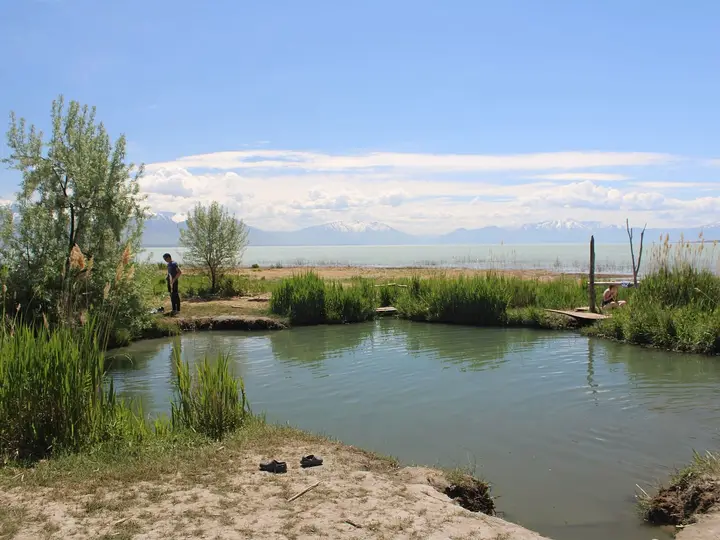
A pair of clear, warm (not hot) springs joined in a horseshoe shape in Skull Valley, managed by the BLM as a wildlife area and stop on the California National Historic Trail.
Photo: BLMUtah (Public domain). Resized and cropped for this page.

- Water temperature
- Not published
- Entry
- Free
- Getting in
- Drive-up
- Type
- Wild & natural
- Two large springs meet in a horseshoe shape, with very clear blue water you can see a long way down into.
- The water is warm by desert-spring standards but well below soaking temperature, and the site is managed for fish and wildlife, not bathing.
- The Donner-Reed party stopped here in 1846 on the Hastings Cutoff, and an interpretive display tells the story.
- Free, a few hundred yards off Skull Valley Road, about 10 miles south of I-80 exit 77.
What to expect
Horseshoe Springs is a warm spring, not a hot one, and it is worth knowing that before you make the drive. Two large springs rise in the floor of Skull Valley, west of the Stansbury Mountains, and their channels join in a curve that gives the site its name. The water is strikingly clear and blue. You can see a long way down into it, and you may spot small fish moving along the bottom.
The Bureau of Land Management runs the site as the Horseshoe Springs Wildlife Management Area. It is managed for riparian, fisheries and wildlife habitat, and the activities the BLM lists are fishing, hiking, wildlife viewing, environmental education and photography. Swimming and soaking are not on that list. Visitor reports put the water in the low 70s°F. That is pleasant on a summer afternoon but far below the 100°F38°C or more that most people want from a hot spring.
So think of this as a desert spring walk with history, not a soak. Some people do get in for a swim on hot days. If you do, keep it short, enter where the bank is already bare, and leave the vegetation alone. The surrounding channel water is brackish, so it tastes slightly salty.
The site has a visitor kiosk, an interpretive display about the California National Historic Trail, and a tactile exhibit. A wooden boardwalk used to give access around the springs for fishing, but recent visitor reports say it has been destroyed and it is not clear whether it will be rebuilt. A dirt trail still loops around the water, about 0.4 miles in total and almost flat.
History
People were using these springs long before roads reached Skull Valley. The NPS and BLM note that the local Goshute people used the area extensively. In 1827 the trapper and explorer Jedediah Smith passed through on his way back from California, the first recorded visit by a white traveler.
In 1846 the springs became a stop on the Hastings Cutoff, the shortcut across the Great Salt Lake Desert that the Donner-Reed party took on their way to California. Water was scarce on that route, and the NPS describes Horseshoe Springs as an important desert water source for the Donner Party and the travelers who followed. Gold rush travelers used it later. The site now sits on the California National Historic Trail, and the interpretive panel covers that story.
The ghost town of Iosepa, founded by Hawaiian Latter-day Saint settlers in the late 1800s, is about 10 minutes south on the same road and makes an easy second stop.
Getting there
Horseshoe Springs is in Tooele County, west of Salt Lake City.
- From Salt Lake City: Take I-80 west past Tooele and the Great Salt Lake. Leave at exit 77 (Dugway, Rowley). Drive south on SR-196, Skull Valley Road, for about 9.6 to 10 miles. Around mile post 27, the site is signed on the right (west).
- Final stretch: A good dirt road runs a short distance to the parking area, a few hundred yards from the highway. From the lot you cross a small bridge over a narrow canal to reach the springs, which are right by the parking.
Any car can make it in dry weather. Fill up on fuel and water before you leave I-80. There are no services in Skull Valley near the springs.
When to go
The site is open year-round for day use.
Fall, winter and early spring are the best seasons. The air is cool and wildlife is easier to spot. Winter visits are popular with photographers.
Late spring through early fall brings heavy mosquitoes, gnats and biting flies around the water. Bring repellent and long sleeves if you visit in those months. Summer afternoons in Skull Valley are also very hot and exposed, with little shade.
Crowds are rarely a problem. You may share the site with a few anglers or birders.
Rules and etiquette
- Day use only. The BLM does not allow overnight camping at the springs.
- It is a wildlife area. Stay on the trail, keep dogs leashed and out of the water, and do not disturb nesting birds or fish.
- Swimming is not a listed use. If you get in, do it quietly and briefly, and do not use soap, sunscreen-heavy lotions or anything else that ends up in the water.
- Fishing is one of the listed uses. Follow Utah Division of Wildlife Resources fishing rules and carry a valid Utah fishing license.
- Pack out everything. There are no trash cans or restrooms.
- Wear a swimsuit if you go in. This is a public roadside site.
Where to stay nearby
- Horseshoe Knoll across the road is BLM land used for dispersed camping and off-highway riding, and it is the usual base for people who want to stay the night. Expect no facilities.
- Grantsville and Tooele, east of the Stansbury Mountains, are the nearest towns with motels, restaurants and fuel.
- Salt Lake City is close enough to make this a day trip.
Safety notes
- Remote desert: Skull Valley is sparsely populated and cell service is patchy. Carry water, food and a full tank, and tell someone your plans.
- Heat and sun: There is almost no shade. Summer days can be dangerously hot.
- Clear water: Very clear water makes depth hard to judge. Do not jump in, and keep children close.
- Soft banks: The edges can be marshy or undercut. Stay on the trail, especially now that the old boardwalk is gone.
- Bugs: Mosquitoes and biting flies are heavy in warm months.
- Dugway Proving Ground is a military reservation farther south in the valley. Respect all signed boundaries.
Nearby stops worth adding
Iosepa, about 10 minutes south on SR-196, has a cemetery and memorial from the Hawaiian settlement. The Skull Valley drive itself is a quiet stretch of West Desert scenery between the Stansbury and Cedar Mountains. On the way back east, the Great Salt Lake shoreline along I-80 has several pullouts.
Map and nearby springs
GPS: 40.61427, -112.70904
Horseshoe Springs: common questions
Can you swim at Horseshoe Springs?
The BLM lists fishing, hiking, wildlife viewing and photography here, and does not mention swimming. It is managed as a wildlife management area for fish and riparian habitat. Some people do get in, but it is not a developed swimming or soaking site. If you go in, keep it brief and stay off the banks and vegetation.
Is Horseshoe Springs a hot spring?
No. It is a warm spring. Visitor reports put the water in the low 70s°F, which is about the temperature of an unheated pool in summer. Do not come expecting a hot soak.
How do you get to Horseshoe Springs?
Take I-80 west from Salt Lake City to exit 77 (Dugway, Rowley). Drive south on SR-196, Skull Valley Road, for about 10 miles. The site is signed on the right (west), and a short dirt road leads to the parking area.
Can you camp at Horseshoe Springs?
No. The BLM does not allow overnight camping at the springs. Dispersed camping is common on BLM land in the Horseshoe Knoll area across the road. Check the BLM Salt Lake Field Office for current rules.
Are there restrooms at Horseshoe Springs?
No. There are no restrooms, water or trash service. There is a visitor kiosk and an interpretive display for the California National Historic Trail.
Closest hot springs to Horseshoe Springs
102°F39°C
Resort or spa
Near Ogden
Wild & natural
Ogden Hot Springs (Ogden Canyon Hot Pots)
Utah, United States
59 mi away, ~1.5 hr drive
Temp n/a Paid Short walk
90-96°F32-36°C
Resort or spa
103-113°F39-45°C
Wild & natural
Stinking Hot Springs (Stinky Springs)
Utah, United States
71 mi away, ~2 hr drive
103-113°F39-45°C Free Drive-up
All hot springs in UtahAll hot springs in United StatesOpen the full map