Echo Rock Hot Springs
Oregon, United States
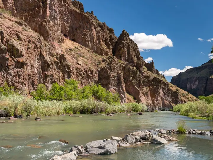
A small concrete soaking pool on a hillside above the Owyhee River arm of Owyhee Reservoir, across from the cliff called Echo Rock, reached by a 4-mile paddle or a low-water walk from Leslie Gulch.
- Water temperature
- Not published
- Entry
- Free
- Getting in
- Boat access
- Type
- Wild & natural
- The pool sits across the water from Echo Rock, a tall canyon wall, and a white pipe on the shore marks the spring.
- Most visitors paddle about 4 miles of flatwater from the Leslie Gulch launch.
- Leslie Gulch, with its red rhyolite towers and free BLM campground, is the base for the trip.
- Reservoir level changes everything, so the same trip can be a paddle one year and a walk the next.
What to expect
Echo Rock Hot Springs is a primitive soak in one of the emptiest corners of Oregon. Hot water comes out of a hillside above the Owyhee River arm of Owyhee Reservoir and is caught in a concrete pool that looks across the water to a tall wall of rock called Echo Rock. A white pipe on the shore marks the spot. From the water, you pull up on the bank and walk up a small hill to the pool.
One writer who paddled in from Leslie Gulch in 2010 found a large pool of clean, steaming water at 103°F39°C, with a wide view of the canyon. There may be more than one pool, depending on who has been working on them. A 2015 visitor report notes that the pools were clean after some cleanup and that the water flow can be controlled. That same report warns that the upper pools can collect cow dung, since cattle graze the surrounding range. They are easy to empty and refill.
Do not expect anything else. There are no toilets, no shade structure, no trash cans and no signs. The appeal is the setting: red and tan canyon walls, the quiet of the reservoir, and the chance of having the pool to yourself. If you climb the plateau above the spring, the view opens out across the Owyhee country toward Steens Mountain on a clear day.
Federal land-status data shows the spring on Bureau of Reclamation land around Owyhee Reservoir. The surrounding Owyhee Canyonlands are public land managed by the BLM Vale District.
Getting there
Echo Rock is about 3.5 miles west-southwest of Slocum Creek Campground, near the mouth of Leslie Gulch, on the east side of Owyhee Reservoir. Leslie Gulch is the only practical starting point.
Driving to Leslie Gulch: The BLM’s directions start on US 95 in Idaho. Go west about 8 miles on McBride Creek Road to Rockville, then about 1 mile north to Leslie Gulch Road, and follow it about 15 miles west down the canyon to the reservoir. You can also reach the Leslie Gulch Road junction via Succor Creek Road from Oregon Highway 201 or US 95. The roads are gravel and dirt. The BLM recommends a high-clearance vehicle because flash floods, wet weather and winter conditions can make the road impassable, and it does not recommend large RVs. A 2010 visitor reported getting a Prius in on a dry day, but do not count on that after rain.
By boat: This is the usual way in. From the Leslie Gulch launch area, paddle about 4 miles of flatwater upstream along the reservoir to the white pipe across from Echo Rock. A sea kayak or a stable canoe is ideal. Plan for wind, which can kick up chop on the reservoir in the afternoon.
On foot: When the reservoir is drawn down, the shoreline and old canyon floor open up, and soaking guides describe a walk of about 3.5 miles each way from Leslie Gulch along the river. In high water the route can be under water, and you would need to paddle. There is no maintained trail, so carry a map or GPS track and allow time to pick your way over rough ground.
Note that overnight backpacking is not allowed in the Leslie Gulch Area of Critical Environmental Concern, so this is a day trip from the campground unless you camp elsewhere outside the ACEC.
When to go
Owyhee Reservoir is an irrigation reservoir, so its level rises and falls a long way through the year. That swing decides whether you walk, paddle or find the shoreline route flooded.
Late fall through early spring is the usual recommendation. The reservoir is lower, the air is cool enough to make a hot pool appealing, and you avoid the heat of an Owyhee summer. Bring layers, because desert nights get cold.
Spring runoff can raise the water and flood the low-water route. This is also the main season for float trips on the Owyhee River upstream, which typically run from March to June.
Summer is hot, exposed and not much fun for a 103°F39°C soak. If you go, start early and carry plenty of water.
Whatever the season, Leslie Gulch Road is the weak link. A thunderstorm or snow can close it for days.
Rules and etiquette
- Pack out everything, including human waste near the pool. There are no facilities.
- No glass at the pool or on the shore.
- No soap or shampoo in the pools.
- Leave the pool clean. If you drain and refill a pool, leave it full for the next person.
- Leslie Gulch rules: inside the Leslie Gulch ACEC, camping and fires are limited to Slocum Creek Campground, the stay limit is 14 days, vehicles must stay on existing roads and parking areas, and collecting plants, rocks or firewood is prohibited.
Clothing is generally optional at the pool. Families can visit, but this is a rough, remote trip that suits experienced paddlers and hikers better than young children.
Where to stay nearby
- Slocum Creek Campground is a small BLM campground in a side canyon near the mouth of Leslie Gulch. It has nine sites, some with accessible features, and accessible vault toilets. There is no fee and no drinking water. Stay limit 14 days.
- Lake Owyhee State Park, near the north end of the reservoir by Owyhee Dam, is far by road from Leslie Gulch but has developed camping. Check road routes carefully if you plan to use both.
- The nearest towns with services are in the Treasure Valley on the Idaho side of US 95, such as Marsing and Homedale, and Jordan Valley to the south. Fill up on fuel and water before you leave the highway.
Safety notes
- Remoteness: There is usually no cell service in Leslie Gulch or on the reservoir. Tell someone your plan, carry a satellite messenger if you have one, and bring a spare tire.
- Water: Bring all your drinking water. Slocum Creek Campground has none, and the reservoir and spring water are not safe to drink untreated.
- Paddling: Wear a life jacket. Wind on Owyhee Reservoir can build quickly, and a 4-mile return paddle into a headwind takes much longer than the trip out.
- Heat and cold: Summer days are very hot with little shade. Winter brings freezing nights and the chance of snow on the road.
- Footing: The bank up to the pool and the low-water route are loose and uneven. Wear proper shoes.
- Water quality: Cattle use the area. If a pool looks dirty, drain and refill it before soaking, and keep your head above water.
- Rattlesnakes are common in the Owyhee canyons in warm months. Watch where you put your hands on the rocks.
Nearby stops worth adding
Leslie Gulch itself is worth the drive even without the spring. The road winds through towers and honeycombed walls of red rhyolite, and short hikes up side canyons like Juniper Gulch lead into the formations. Bighorn sheep live in the area. If you want a more accessible hot soak in the Owyhee country, Snively Hot Springs is on the Owyhee River below Owyhee Dam, a long drive north around the reservoir.
Map and nearby springs
GPS: 43.30170, -117.38299
Echo Rock Hot Springs: common questions
How do you get to Echo Rock Hot Springs?
Most people launch a kayak or canoe at the end of Leslie Gulch Road and paddle about 4 miles up the Owyhee arm of Owyhee Reservoir. The spring is on the shore opposite the cliff of Echo Rock, marked by a white pipe. When the reservoir is drawn down, some visitors walk the canyon floor instead, about 3.5 miles each way.
How hot is Echo Rock Hot Springs?
A 2010 visitor measured the pool at 103°F39°C. Temperature varies with flow and season, and there is no posted reading, so test the water before getting in.
When is the best time to visit Echo Rock Hot Springs?
Late fall to early spring, when the reservoir is low and the weather is cool enough to enjoy hot water. High water in spring and early summer can flood the shoreline, and Leslie Gulch Road can be impassable after storms or snow.
Can you camp near Echo Rock Hot Springs?
Yes, at Slocum Creek Campground near the mouth of Leslie Gulch. It is a free BLM campground with nine sites and vault toilets but no drinking water. Inside the Leslie Gulch Area of Critical Environmental Concern, camping is only allowed in the campground.
Is Echo Rock Hot Springs clothing optional?
Soaking guides describe it as generally clothing optional. It is remote and rarely busy, but bring a suit in case others are there.
Closest hot springs to Echo Rock Hot Springs
Near Rome
Wild & natural
Near Rome
Wild & natural
105-115°F41-46°C
Wild & natural
99°F37°C
Wild & natural
All hot springs in OregonAll hot springs in United StatesOpen the full map